
World's greatest classroom
.jpg)
.jpg)
Nothing beats The Colorado Plateau in general and southern Utah in particular when it comes to field-based learning about the deposition and deformation of sedimentary rocks. With its many world class field localities, excellent degree of exposure, nice weather and simple logistics, it is the perfect place for a geology field trip that focuses on siliciclastic sediments and/or salt tectonics.
Every year we run a field course for graduate students at the Department of Earth Science in Bergen to Utah. Every year this course is a great success, although work intensive for the students who also have to deal with seismic data, drilling prospects ant other exercises in addition to their short morning presentation of the highlights of the previous day.
I started running field trips together with Jonny Hesthammer while working for Statoil back in the early 1990s. After more than 50 groups of students and geoscientists, I still run field trips for oil companies every spring and/or fall. My field of expertice is structural geology, but I commonly team up with sedimentologists such as John Howell to offer a more complete field trip that covers both deposition and deformation of silisiclastic rocks.
Research based field trips
The field trips are based on my 20 years of field-based research in the area. Research has been fucused on structural geology, covering faults, folds, fractures and deformation bands. I have (had) a number of PhD and MS students working in this area.
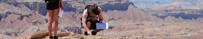
.jpg) It is important to me that the participants get enough time to absorb a significant amount of information from the outcrops. Scetching is very useful for this purpose. Further, the participants make their own measurements at some of the localities before we share and discuss the results. Such exercises could be measuring populations of subseismic fracture or deformation band populations, measuring permeability with a mini-permeameter, or study differences in structural expression between layers of different grainsize or permeability.
It is important to me that the participants get enough time to absorb a significant amount of information from the outcrops. Scetching is very useful for this purpose. Further, the participants make their own measurements at some of the localities before we share and discuss the results. Such exercises could be measuring populations of subseismic fracture or deformation band populations, measuring permeability with a mini-permeameter, or study differences in structural expression between layers of different grainsize or permeability. .jpg)
Oil company groups are encouraged to bring their own examples in the form of seismic profiles, maps and well information for disccussion in the field. Some of the discussions we have had in the field over a real problem have been very useful and enlightening for many of us, particularly when geoscientists of different background are put together.
U of Bergen students working out details at Bartlett Wash.
Faults, fractures and deformation bands
.jpg) Many examples of faults, normal mostly, but also reverse and oblique slip, can be found to affect the sedimentary sequence of the Colorado Plateau. They range from the smallest slip surfaces to the multi-km-size faults delimiting the plateau to the west. The Moab fault system is one of the most beautiful exposures of a medium-sized fault (0-1 km offset), the premium exposure being the Bartlett fault segment NW of Moab, as shown in the picture to the left (from my textbook). Deformation bands, fault lenses, and the fault damage zone can be studied at this locality down to tne smallesd detail. It also comes with an impressive hanging-wall drag zone. On top of all of this are some amazing joint systems that are easily visible from the air (and Google Earth) and play an important role in the formation of the many natural arches in the area. These extensionfractures or joints postdate the formation of faults and deformation bands on the plateau and are at least partly a result of cooling, decompression and tectonic stress during the relatively recent uplift of the Colorado Plateau.
Many examples of faults, normal mostly, but also reverse and oblique slip, can be found to affect the sedimentary sequence of the Colorado Plateau. They range from the smallest slip surfaces to the multi-km-size faults delimiting the plateau to the west. The Moab fault system is one of the most beautiful exposures of a medium-sized fault (0-1 km offset), the premium exposure being the Bartlett fault segment NW of Moab, as shown in the picture to the left (from my textbook). Deformation bands, fault lenses, and the fault damage zone can be studied at this locality down to tne smallesd detail. It also comes with an impressive hanging-wall drag zone. On top of all of this are some amazing joint systems that are easily visible from the air (and Google Earth) and play an important role in the formation of the many natural arches in the area. These extensionfractures or joints postdate the formation of faults and deformation bands on the plateau and are at least partly a result of cooling, decompression and tectonic stress during the relatively recent uplift of the Colorado Plateau.
.jpg)
Statoil employees discussing deformation band clusters: How would they affect fluid flow during oil production?
Why a Colorado Plateau field trip is so great:
• Exceptional exposures
• Perfect climate and weather
• Easy logistics
• A variety of silisiclastic rocks (continental and marine)
• Many of the sandstones have high porosity
• Much research has been done (and more is going on)
.jpg)
Some localities
✓ Salt Lake City area: Large-scale fault geometries
✓ Thistle-Skyview: Smaller Cenozoic faults.
✓ Book Cliffs: Delta deposits, sequence stratigraphy.
✓ Arches Nat’l Park: Moab fault, fault core, deformation bands, relay structures.
✓ Bartlett Wash: Structure and anatomy of single fault
✓ Courthouse: Fault branch point, cementation, fault growth
✓ Grabens area, Canyonlands: Grabens, growth of fault populations and the formation and destruction of relay ramps.
✓ Onion Creek: Salt diapir, caprock.
✓ Upheaval Dome: Probably an impact structure.
✓ Ketobe Knob: Reverse faulting of Entrada Sandstone
✓ San Rafael Desert: Fault growth in porous sandstones. Deformation bands.
✓ Salina, smear
✓ Colorado Nat’l Monument and San Rafael Reef: Fault propagation through sandstones, drag, monoclinals.
✓ Buckskin Gulch: Compaction bands.
.jpg)
And then there are other fun things to do too....jpg)
Resources
Geologic maps of Utah
Utah Geological Survey
Aerial photos, Utah
Video (in Norwegian) Part 1 and Part 2