
So special, so diverse, so butiful
 The Colorado Plateau is so packed with world-class geologic features that choosing your subject becomes a challenge itself. It has the shallow intrusions called laccoliths that were subjected to classical studies, notably the Henry Mountains. In the west there is the fold-and-thrust belt of the Sevier orogeny, overprinted by extensional faults of the Basin and Range province. Farther east there is the Laramide orogeny, which created very interesting basement reactivations and associated forced folding or fault propagation folding of the sedimentary cover. The various structures can be seen in rocks and sediments spanning from Precambrian to Quaternary in age, with Permo-Jurassic eolian deposits and Cretaceous deltaic/marine deposits as important components. I have focused my research on fault-related structures in silisiclastic deposits, particularly eolian and related strata of the Navajo and Entrada sandstones.

From salt via eolian structures to delta deposits
You have to drill to really get to the salt of the Carboniferous Paradox Formation, because any exposed halite has been washed out, leaving just a caprock at and close to the surface. The caprock with its anhydritic layers can be seen several places, perhaps best at the Onion Creek salt diapir.
 The Permian-Jurassic part of the sedimentary sequence on the plateau is dominated by eolian sandstones, many of which stand out as cliff-forming units with superb cross-stratification enhanced by color variations that typically can be explained in terms of permeability and red-ox relations during paleo-fluid flow. The Navajo Sandstone and the Entrada Sandstone are probably the best studied units.
A change in climate, increase in sea level, and loading by the Sevier fold-and-thrust-belt in Nevada and western Utah llead to a less arid and eventually marine conditions on much of the plateau in the Cretaceous. When the Western Interior Seaway was established as a foreland basin, delta systems built out from the Sevier mountains in the west (Mesa Verde Group), interfingering with marine shale (Mancos Shale). Stratigraphers love the extensive exposures of these Cretaceous deposits in the Book Cliffs, where sections run along as well as across this enormous paleo-delta system that serve as an analog to several deltaic reservoir units in the world, for example the Brent Group of the North Sea.  Monument Valley.
Faults, fractures and deformation bands
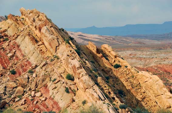
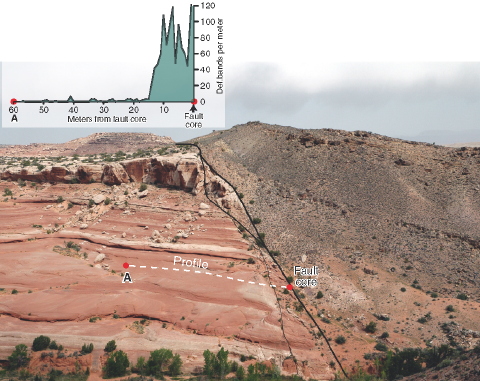 Many examples of faults, normal mostly, but also reverse and oblique slip, can be found to affect the sedimentary sequence of the Colorado Plateau. They range from the smallest slip surfaces to the multi-km-size faults delimiting the plateau to the west. The Moab fault system is one of the most beautiful exposures of a medium-sized fault (0-1 km offset), the premium exposure being the Bartlett fault segment NW of Moab, as shown in the picture to the left (from my textbook). Deformation bands, fault lenses, and the fault damage zone can be studied at this locality down to tne smallesd detail. It also comes with an impressive hanging-wall drag zone. On top of all of this are some amazing joint systems that are easily visible from the air (and Google Earth) and play an important role in the formation of the many natural arches in the area. These extensionfractures or joints postdate the formation of faults and deformation bands on the plateau and are at least partly a result of cooling, decompression and tectonic stress during the relatively recent uplift of the Colorado Plateau.
 Fractures in Arches National Park.
Salt tectonics
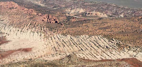
Salt has been moving in the Paradox basin around Moab since the Permian, influencing depositional patterns and creating significant thickness variations and causing angular unconformities. Today we have a series of salt walls with collapsed crests populated by normal faults, including the Moab Fault.
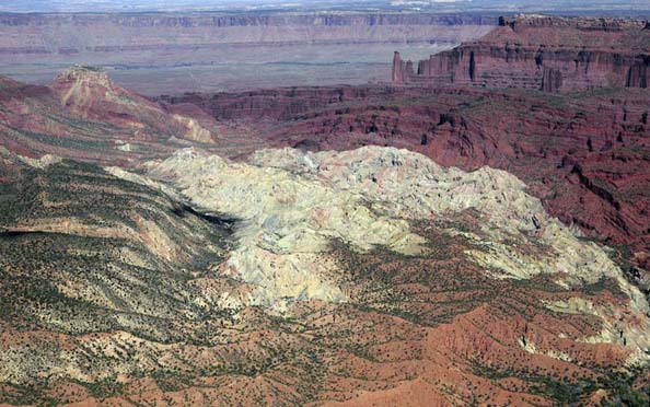 Onion Creek diapir. Caprock with anhydrite layers is light greenish while country rock is red.
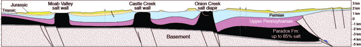 Salt structures of the Paradox Basin in cross-section.
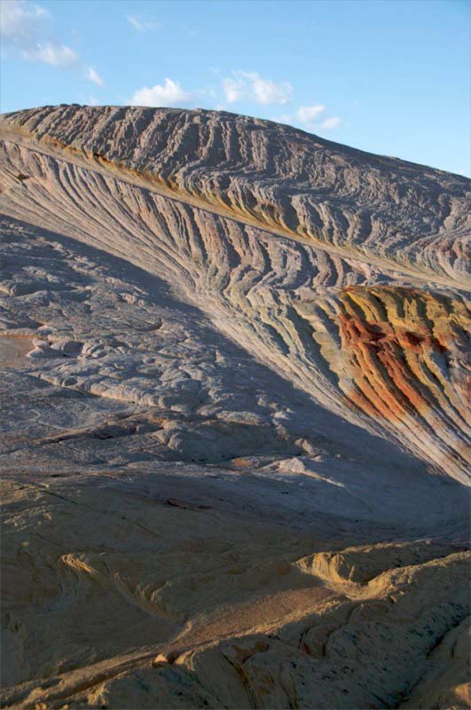
Upheaval dome: Meteor impact structure(?)
In the northern part of Canyonlands National Park lies a peculiar circular structure known as Upheaval Dome. It was originally interpreted as a collapsed salt stock, but an alternative interpretation as a 60 million years old meteor impact structure has become more popular. A recent report of shocked (high-P) quartz provides strong support in favor of the impact theory, but some say it is still possible that salt may have been activated as a result of such an impact and hence contributed to the present structure.
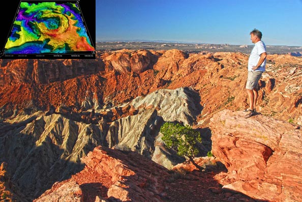 Upheaval Dome: photo and elevation model (inset)
Laccolith intrusions
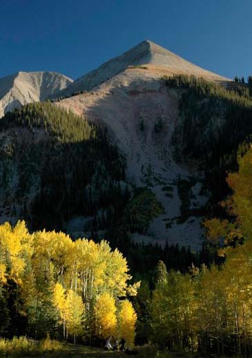 In the middle of redrock country are some oases of igneous rocks known as laccoliths. These shallow intrusions, which I read about in my first geology textbook but did not see an example of until I came to Utah as a professional geologist long thereafter, are amazing. They inflate at shallow levels between layers of sedimentary strata, pushing the overburden up into a dome structure. In the Colorado Plateau this happened some 25 Ma, and the overburden is now eroded away, leaving beautiful alpine mountains that expose porphyritic rocks and hosts a whole different ecosystem. The Henry Mountains are the classical area for laccoliths, while the La Sal Mountains near Moab are the tallest (almost 4000 m) and probably the example most noticed by tourists, easily spotted from the Moab and Arches National Park area.
What makes it so great:
•Exceptional exposures
•Well studied, but still plenty of stuff to be explored
•Large specter of sedimentary rocks
•Well-exposed fault systems
•Beautiful fault propagation folds
•Close sedimentation–tectonics relationships
•Offers both large- and smallscale observations
•Accessible with lots of public land and parks
•Easy logistics
•Plenty of sunshine and nice weather!
Deformation bands
•Caracteristic small-scale deformation features of the Colorado Plateau sandstones.
Resources
Geologic maps of Utah
Utah Geological Survey
Aerial photos, Utah
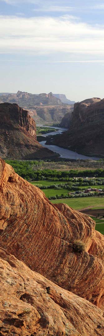
View of the Colorado River from the Slickrock Bike Trail across the Moab Valley. Note dipping layers across the valley, rotated during the evolution of the Moab Valley salt wall.